
Myres Hill Cairn
Carrot
Eaglesham
Renfrewshire
NGR - NS 574470
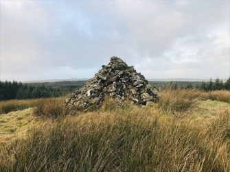
The Myres Hill Cairn is located on the brow of an eastern part of Myres Hill, south-west of Carrot farm. Access is by walking through afforested areas and rough terrain.
Myres Hill Cairn
On the eastern slopes of Myres Hill, to the south of Eaglesham in Renfrewshire, stands a prominent cairn. This has been rebuilt over the years, but it traces its origins to the time of the Covenanters. The cairn was built from the remains of a sheepfold, itself probably built from the stones of a Bronze Age burial cairn. The cairn was rebuilt by Robert Cunningham. The cairn was said to have been a lookout point for when conventicles were being held at the nearby Preaching Braes. According to Andrew Renfrew, writing in Reminiscences of Old Eaglesham, published by Eaglesham Woman’s Guild in 1929, ‘from its seclusion, this was a favourite meeting-place with the Covenanters during the times of persecution, and at a spot known as the “Minister’s Knowe,” Richard Cameron, with Bible in hand, was addressing a meeting one Sunday when they were surprised by Deputy Sheriff Hume, of Eaglesham, a bitter persecutor, and a small company of dragoons, all on horseback. Hume ordered the Covenanters to disperse in the name of the King. Cameron replied that they owned allegiance to no king but the King of Kings. The Covenanters, who were armed, gathered round rather menacingly, and the Sheriff thought it better to retire without having effected his purpose. Cameron severely denounced him and said that he would come to an untimely end, which prophecy was soon fulfilled, for after the Reformation [sic—Revolution], which happened after Hume fell into disgrace with the Government and was dismissed an, as no one would employ him, he died in great poverty. It was told that he went about the parish begging, and on being assisted by some of those whom he had persecuted, he would say that they were heaping coals of fire on bis head.’
For some unknown (and probably unlikely) reason, the Whitelee rangers refer to this as the Viking Princess Cairn.
| Visitor Counter: | |||||||
 |  |  |  | |  | ||